Chapter 8 ~ Biomes and Ecozones
Key Concepts
After completing this chapter, you will be able to
- Identify the major biomes and outline their characteristics.
- Identify Canada’s ecozones.
- Describe the differences between natural and anthropogenic ecosystems.
Biomes: Global Ecosystems
A biome is a geographically extensive type of ecosystem. A particular biome occurs wherever environmental conditions are suitable for its development, anywhere in the world. Biomes are characterized by the life forms of their dominant organisms, but not necessarily by their particular species. On land, biomes are generally identified by their mature or older-growth vegetation. In contrast, aquatic biomes are usually distinguished by their dominant animals. Biomes are classified using a system that is used at an international level—that is, by ecologists working in many countries.
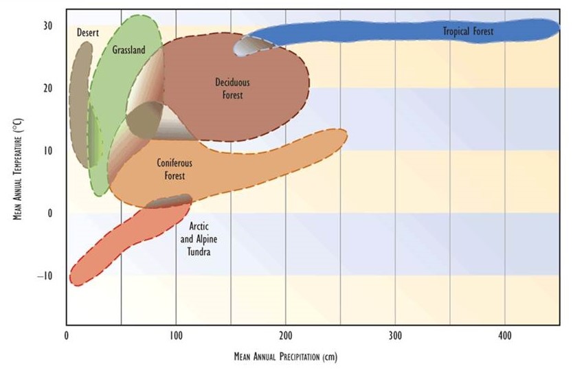
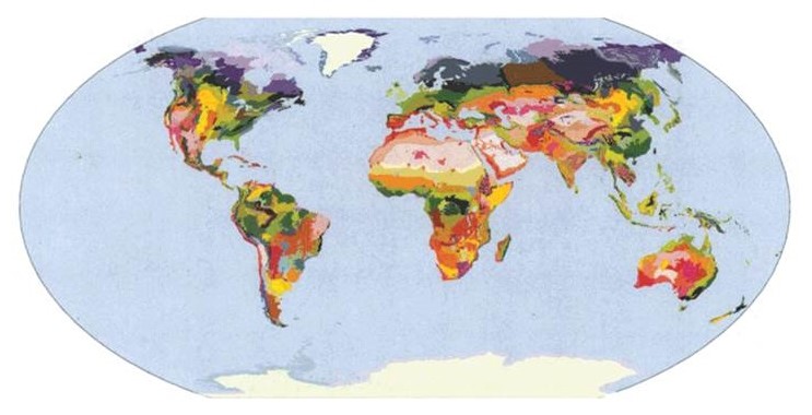
Figure 8.1 shows a map of the distribution of the most extensive terrestrial biomes. The distribution of biomes is determined by environmental conditions, which must be appropriate to support the dominant species. Moisture and temperature are usually the most important environmental influences on the distribution of terrestrial biomes (Figure 8.2). The distribution of various types of wetlands within terrestrial biomes is mostly influenced by the amount and permanence of surface water and the availability of nutrients. Marine biomes are most strongly influenced by water depth and upwellings, which affect the amounts of light and nutrients that are available to support primary productivity.
Figure 8.1. Distribution of the Major Terrestrial Biomes. Note that the spatial complexity is greatest in regions with mountainous terrain, such as the western Americas and southern Asia. Source: Modified from Odum (1993).
](../assets/figure8_1.jpg)
Figure 8.2. Environmental Influences on the Distribution of Terrestrial Biomes. This diagram suggests the reasons why temperature and moisture are believed to be the most important environmental factors affecting the distributions of terrestrial biomes. Source: Modified from Odum (1993).
As long as environmental conditions are suitable for its development, a particular biomes may occur in widely divergent regions, even on different continents. Although widely separate regions of a biome may be dominated by different species, their life forms are typically convergent. In other words, the different species are comparable in their form and function, because the regimes of natural selection occurring in similar environments result in parallel (or convergent) evolutionary responses. Therefore, biomes are defined primarily by the structure and function of their ecosystem, but not necessarily their species composition.
This context is illustrated by the boreal forest, an extensive biome that occurs in northern regions of Canada, Alaska, and Eurasia. The boreal forest occurs in regions with a cold and long winter, short but warm summer, and generally moist soil. This biome is situated between the more northern tundra, and temperate forest or prairie to the south. The dominant vegetation of boreal forest is typically coniferous trees, especially species of fir, larch, pine, or spruce. However, the particular species vary from region to region, and angiosperm (hardwood) trees may also be present.
Over much of northern Canada the boreal coniferous forest is dominated by stands of black spruce (Picea mariana). However, in some regions, stands of white spruce (Picea glauca), jack pine (Pinus banksiana), balsam fir (Abies balsamea), or tamarack (Larix laricina) are dominant. In the boreal forest of northern Europe, Siberia, and northern parts of Japan, Korea, and China, there are other species of coniferous trees. In some cases, there may be stands dominated by hardwood trees, such as trembling aspen (Populus tremuloides) in parts of northern Canada. However, all of these different forest types occurring on several continents are structurally and functionally convergent ecosystems within the same biome—the coniferous forest.
We should also note that any particular biome is described on the basis of its dominant, most extensive kind of ecological communities. For the boreal forest, this is usually stands of coniferous trees. However, biomes are not homogeneous, and they contain other kinds of less-widespread communities. For instance, parts of the boreal forest are dominated by persistent areas of shrubs such as species of alder, dwarf birch, and willow, and there may also be wetlands such as bogs and fens as well as distinctive communities associated with streams and rivers.
In addition, local areas may be subjected to occasional catastrophic disturbances, which may result in a landscape being composed of a mosaic of stands of various stages (and ages) of ecological recovery, called succession. In the case of boreal forest, disturbances are typically caused by wildfire or by epidemics of insects that kill trees (see Chapter 22).
The Major Biomes
Natural biomes are characterized by their dominant ecological communities, which are composed of particular assemblages of plants, animals, and microorganisms. There are also anthropogenic ecosystems that are strongly influenced by humans and their activities, such as cities and agricultural land. In fact, all of the modern biomes have been influenced by people to some degree—at the very least, all organisms in even the most remote places now contain trace contaminations of organochlorine chemicals (such as DDT and PCBs) that humans have manufactured and dispersed into the environment (see Chapter 22).
Ecologists have used a number of systems to divide the biosphere into major biomes, one of which is illustrated in Figure 8.1. The classification of global biomes described here is modified from a system proposed by the ecologist E.P. Odum. In the following sections, the world’s biomes are examined within global and ecoregional contexts. This is appropriate because biomes are widespread ecological units whose boundaries and species do not respect political boundaries.
Terrestrial Biomes
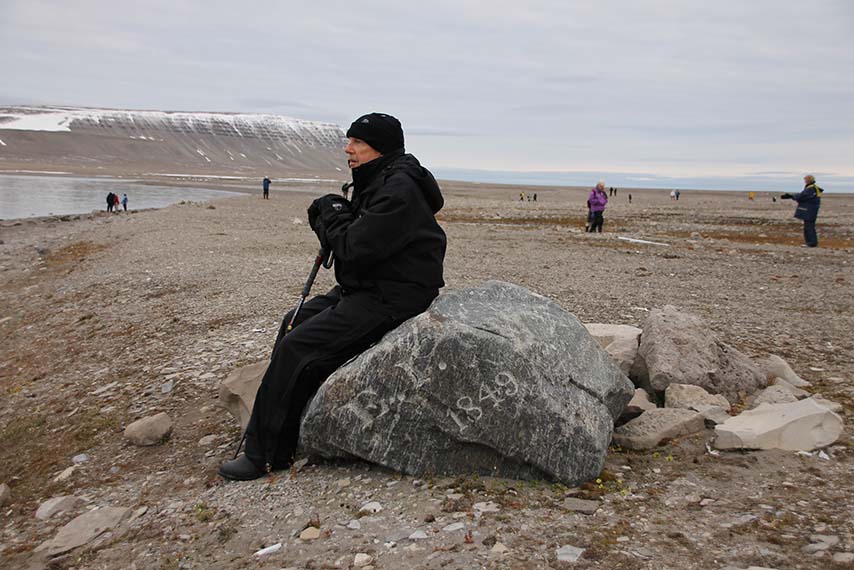
Tundra is a treeless biome that occurs in environments with a long, cold winter and a short, cool growing season. There are two types of tundra: alpine and arctic. Alpine tundra occurs at higher elevations in mountainous regions, even in tropical countries. Arctic tundra occurs at high latitudes—that is, in northern regions of the Northern Hemisphere and southern parts of the Southern Hemisphere. Most tundras are a meteorological desert because they receive sparse precipitation. Nevertheless, the soil may be moist or wet because the cold environment restricts the amount of evaporation that occurs, and frozen soil may prevent deep drainage of water. The coldest, most northerly, high-Arctic tundra is extremely unproductive and dominated by short, long-lived plants, generally growing less than 5-10 cm above the surface. In the less-cold environments of the lower Arctic, well-drained tundra may be dominated by shrubs growing as tall as 1-2 m, while wetter habitats support productive meadows of sedge, cottongrass, and grass.
Image 8.1. Tundra is a biome of short vegetation growing in climatically stressed environments of the Arctic and Antarctic and on mountaintops. This is a view of arctic tundra on northeastern Somerset Island. The rock was marked by James Ross, who from 1848 to 1849 commanded the first search for John Franklin’s expedition, and overwintered at the site. The initials E. I. refer to his ships, the Enterprise and Investigator. Source: B. Freedman.
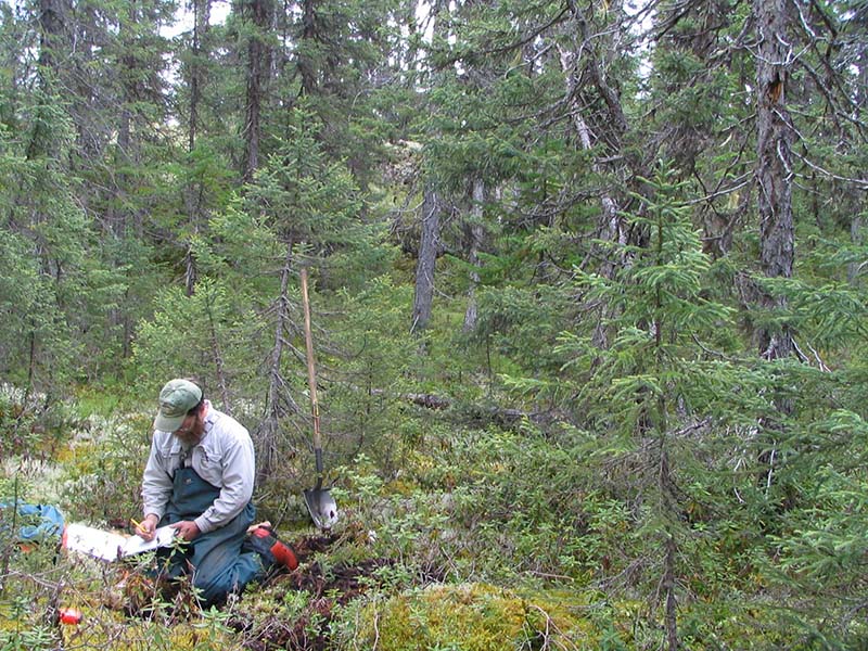
Boreal coniferous forest, or taiga, is an extensive biome of environments with a cold winter, short but warm growing season, and moist soil. It is most extensive in the Northern Hemisphere. The boreal forest is dominated by coniferous trees, especially species of fir, larch, pine, and spruce. Some angiosperm trees may also be prominent, particularly aspen, birch, and poplar. Stands of boreal forest are poor in tree species, and may be dominated by only one or a few kinds. Most regions of boreal forest are subject to periodic disturbances, usually by wildfire, but sometimes by windstorms or insect epidemics.
Image 8.2. The boreal coniferous forest (taiga) is extensive in northern regions of Canada, Alaska, and Eurasia. This photo shows a stand of black spruce with a carpet of feather mosses, in central Labrador. Source: B. Freedman.
Montane forest occurs at sub-alpine altitudes on mountains in temperate latitudes. It is similar in structure to high-latitude boreal forest and is also dominated by conifers.
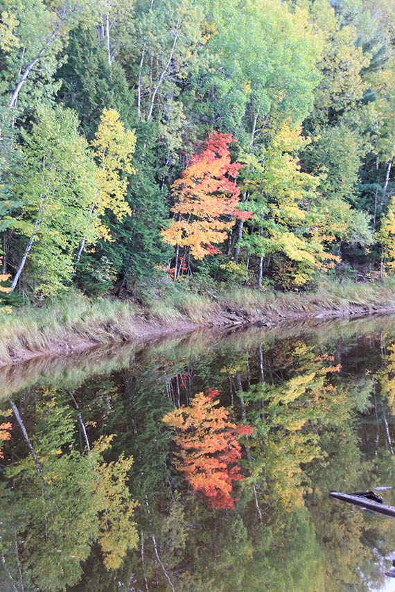
Temperate deciduous forest occurs in relatively moist, temperate climates with a short, moderately cold winter and warm summer. This biome is dominated by a mixture of hardwood tree species. Most of the trees have seasonally deciduous foliage, meaning their leaves are shed each autumn and then regrown in the springtime. This is an adaptation to surviving the drought and other stresses of winter. Common trees of temperate deciduous forest in North America are species of ash, basswood, birch, cherry, chestnut, dogwood, elm, hickory, magnolia, maple, oak, sassafras, tulip-tree, and walnut. These trees occur in distinctive communities based on their preferences for particular qualities of soil moisture and fertility, soil and air temperature, and other environmental factors.
Image 8.3. The temperate deciduous forest contains species of angiosperm trees, which drop their leaves in the autumn, plus some coniferous trees. This biome is widespread south of the boreal forest. This stand in Nova Scotia is dominated by birches, maples, and white spruce. Source: B. Freedman.
Temperate rainforest develops in a climate in which the winter is mild and precipitation abundant year-round. Because this climate is too moist to allow frequent wildfires, old-growth forest often develops. The old-growth forest is dominated by coniferous trees of mixed age and species composition, but some individual trees are extremely large and can be centuries old, sometimes even exceeding a thousand years. Prominent tree species in temperate rainforest of the humid west coast of North America are Douglas-fir, hemlock, red cedar, redwood, Sitka spruce, and yellow cypress.
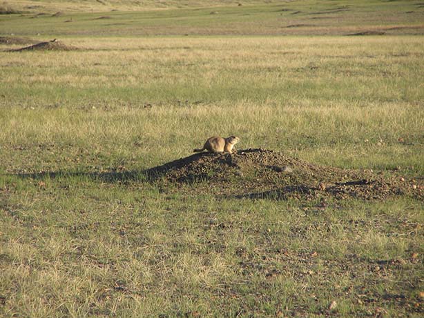
Temperate grassland occurs in temperate regions where the annual precipitation is 25-60 cm/y. Under these conditions, soil moisture is adequate to prevent desert from developing, but insufficient to support forest. Temperate grassland is called prairie in North America and steppe in Eurasia, and this biome occupies vast regions in the interiors of both continents. Prairie is commonly divided into three types according to the height of the dominant vegetation: tall-grass, mixed-grass, and short-grass. Tall-grass prairie is dominated by various grasses and herbaceous angiosperm plants, such as blazing stars and sunflowers, some as tall as 2-3 m. Fire is an important factor that prevents tall-grass prairie from developing into an open forest. Tall-grass prairie is a critically endangered ecosystem because almost all of it has been converted into agricultural land. Mixed-grass prairie occurs where there is less rainfall and the habitat is characterized by shorter species of grasses and herbaceous angiosperms. Short-grass prairie develops where precipitation is even less, and it can be subject to unpredictable, severe drought.
Image 8.4. Temperate grassland is widespread in the dry interior of North America and other continents, and is dominated by species of grasses and other herbaceous plants. This view is of shortgrass prairie in Grasslands National Park in southern Saskatchewan. Source: B. Freedman.
Chaparral develops in south-temperate environments with a so-called Mediterranean climate, with winter rains and summer drought. Typical chaparral is characterized by dwarfed trees and shrubs with interspersed herbaceous vegetation. Periodic fires are characteristic. In North America, chaparral is best developed in coastal southern California.
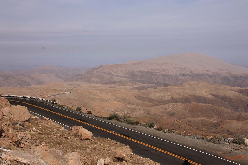
Desert can be temperate or tropical, and it most commonly occurs in continental interiors or in the rain shadow of mountains. The distribution of desert is determined by the amount of soil moisture, which in the temperate zones is generally associated with an annual precipitation of less than about 25 cm. The driest desert supports almost no plant productivity, but less-dry conditions may support communities of herbaceous and succulent plants, both annual and perennial. Occasional moist places with springs of groundwater develop a relatively lush vegetation of shrubs or trees and are known as oases.
Image 8.5. Desert is a sparsely vegetated biome of extremely dry environments. This view is of arid habitat in Peru, in a region where there is no detectable precipitation in some years. Source: B. Freedman.
Tropical grassland and savannah occur in regions with as much as 120 cm of annual rainfall, but a pronounced dry season. Savannah is dominated by grasses and herbaceous angiosperms, with scattered shrubs and tree-sized plants that provide an open canopy. Some tropical grasslands and savannahs support large populations of big animals, including migratory ones. This is particularly true of Africa, where this biome supports a diverse community of large mammals, such as elephant, gazelle and other antelopes, hippopotamus, rhinoceros, water buffalo, and predators of these herbivores, such as cheetah, hyena, leopard, lion, and wild dog.
Semi-evergreen tropical forest develops in a warm climate with pronounced wet and dry seasons. Most trees and shrubs are seasonally deciduous, shedding their foliage in anticipation of the dry season. This biome supports a great richness of biodiversity, though less than tropical rainforest.
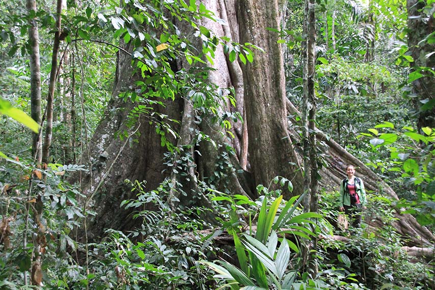
Evergreen tropical rainforest occurs in tropical climates with copious precipitation throughout the year. Tropical rainforest often develops into an old-growth condition because wildfire and other catastrophes are uncommon. Old-growth tropical rainforest supports a tremendous richness of tree species of many sizes and ages, most of which retain their foliage throughout the year. This forest also sustains an extraordinary diversity of other plants, animals, and microorganisms. Tropical rainforest represents the peak of development of terrestrial ecosystems because the biome supports huge biomass, high productivity, and rich biodiversity under relatively benign climatic conditions.
Image 8.6. Evergreen tropical forest occurs in warm regions where rainfall is abundant throughout the year. Tropical rainforest, such as this one in Peru, sustains more species than any other ecosystem. Source: B. Freedman.
Freshwater Biomes
Lentic ecosystems contain standing or very slowly flowing water, as occurs in lakes and ponds. The ecological character of lentic systems is most strongly influenced by water chemistry, particularly its transparency and nutrient concentration. Waters that are well supplied with nutrients are highly productive (eutrophic), while infertile waters are unproductive (oligotrophic). In general, shallow waterbodies are much more productive than deeper ones of a comparable surface area. However, waterbodies with poor transparency are much less productive than might be predicted on the basis of their nutrient supply. Waters that are brown-coloured because of dissolved organic matter have poor transparency, as do turbid waters with fine suspended particulates. Lentic ecosystems are characterized by zonation in two dimensions. Horizontal zonation is due to changes in water depth and is usually related to the slope and length of the shore. Vertical zonation occurs in deeper water and is related to the amount of light, water temperature, and nutrient and oxygen concentrations. Lentic ecosystems often develop distinct communities along their shore (known as the littoral zone), in their deeper open water (the pelagic zone), and on their sediment (the benthic zone).
Lotic ecosystems are characterized by flowing water and include rivers and streams. The quantity, velocity, and seasonal variation of water flow are important environmental factors. Within streams or rivers, silt-sized particles are deposited in places with relatively calm water, leaving a fine-grained or muddy substrate. In contrast, the substrate of places with vigorous water flow is rocky because fine particles have been eroded away. For similar reasons, the turbidity is greatest during times of high water flow. Turbidity is an important factor because it interferes with light penetration and thereby restricts primary productivity. Lotic ecosystems sustain some productivity of algae and aquatic plants, but usually their primary production is not large. Most of the productivity of aquatic invertebrates and fish in lotic ecosystems is sustained by inputs of organic matter from upstream lakes and from the terrestrial watershed in the form of plant debris.
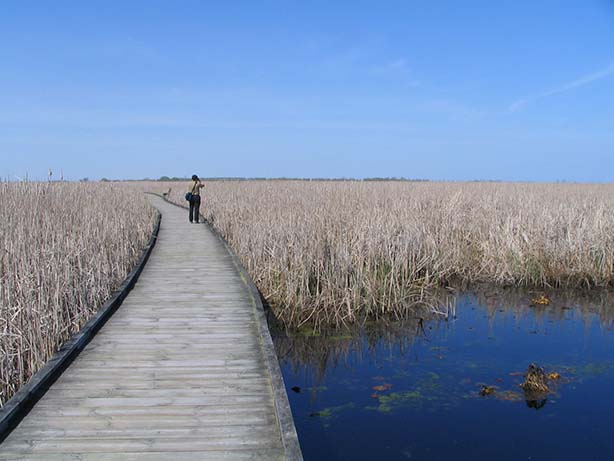
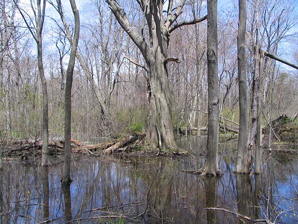
Wetlands occur in shallow, flooded places on land. There are four major types: marsh, swamp, bog, and fen. Marshes are the most productive; they are dominated by plants that are rooted in sediment but grow as tall as several metres above the water surface, such as reed, cattail, and bulrush. Open-water areas of marshes have floating-leaved plants, such as water lily and lotus. Swamps are forested wetlands that may be flooded seasonally or permanently. Swamps are often dominated by such trees as silver maple (Acer saccharinum), white elm (Ulmus americana), or bald cypress (Taxodium distichum). Bogs are acidic, relatively unproductive wetlands that develop in a cool, wet climate. Their supply of nutrients is sparse because bogs are fertilized only by atmospheric inputs of dust and chemicals dissolved in precipitation. Bogs are typically dominated by species of Sphagnum moss (also known as peat moss). Fens also develop in a cool and wet climate, but since they have a better nutrient supply than bogs, they are less acidic and more productive.
Image 8.7. A marsh is a fertile wetland dominated by taller herbaceous plants, such as bulrush and cattail. This images shows a lakeside marsh dominated by cattail (Typha latifolia) in Point Pelee National Park in southern Ontario. Source: B. Freedman.
Image 8.8. A swamp is a forested wetland. This example is dominated by silver maple (Acer saccharinum) in Point Pelee National Park. Source: B. Freedman.
Marine Biomes
The open ocean consists of pelagic and benthic ecosystems. The pelagic (open-water) ecosystem is strongly influenced by physical and chemical factors, particularly waves, tides, currents, salinity, temperature, light intensity, and nutrient concentration. The rate of productivity is small, and comparable to that of terrestrial desert. The primary production is associated with phytoplankton, which range in size from extremely small photosynthetic bacteria to larger (but still microscopic) unicellular and colonial algae. The phytoplankton are grazed by tiny animals known as zooplankton (most of which are crustaceans), which are eaten in turn by larger zooplankton and small fish. Large predators such as bluefin tuna, sharks, squid, and whales are at the top of the pelagic food web. The benthic ecosystem of the open ocean biome is supported by a sparse rain of dead biomass from the surface. The benthic ecosystem of the deep oceans is not yet well described, but it appears to be somewhat rich in species, low in productivity, and extremely stable over time. Some large regions of the open ocean have an enormous rotating surface current known as a gyre, which is caused by the Coriolis effect associated with the rotation of Earth. Gyres in the Northern Hemisphere rotate in a clockwise direction, while those in the Southern Hemisphere are counter-clockwise. Gyres collect floating material, such as floating seaweeds like Sargassum, as well as garbage from coastal dumping and debris from fishing fleets. One example is the North Pacific gyre, which covers most of that oceanic basin, and another is the North Atlantic gyre, also known as the Sargasso Sea.
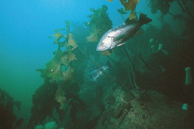
Continental shelf waters occur near the shores of continents and are relatively shallow because they overlie an underwater projection of the landmass (a continental shelf). Compared with the open ocean, these nearshore waters are relatively warm and well supplied with nutrients. The nutrients come from inputs of rivers and from deeper, relatively fertile oceanic water that is occasionally stirred from the bottom by currents or turbulence caused by windstorms. Because the nutrient supply of coastal waters is relatively high, phytoplankton are productive and support a higher biomass of animals than occurs in the open ocean. Some of the world’s most important fisheries are supported by the continental shelf biome – for example, those on the Grand Banks and other shallow waters of northeastern North America, in the nearshore waters of western North and South America, and in the Gulf of Mexico.
Image 8.9. The Pacific continental shelf waters are rich in marine life. Pictured here is a “forest” of large seaweeds known as kelps (Nereocystis spp.), which provide critical habitat for many animals, such as black rockfish (Sebastes melanops). Source: C. Harvey-Clark.
Regions with persistent upwelling occur where local oceanographic conditions favour the upwelling of relatively deep, nutrient-rich water to the surface. The increased nutrient supply allows these areas to sustain high rates of primary productivity. This ecological foundation supports large populations of animals, including big fish, sharks, marine mammals, and seabirds. Some of the most productive fisheries occur in upwelling areas, such as those off the west coast of South America and extensive regions of the Antarctic Ocean.
Estuaries are a complex group of coastal ecosystems that are open to the sea but are semi-enclosed in an embayment. Estuaries are transitional between marine and freshwater biomes, typically having large fluctuations of salinity associated with inflows of fresh water from the nearby land, twice-daily tidal cycles, and marine storm surges. Estuaries typically occur as coastal bays, river mouths, salt marsh, and tropical mangrove forest. They are highly productive ecosystems, largely because their semi-enclosed circulation tends to retain much of the water-borne input of terrestrial nutrients. Estuaries provide critical habitat for juvenile stages of commercially important fishes, shellfish, and crustaceans.
Seashores are an interface of terrestrial and oceanic biomes and they support a complex of coastal ecosystems. The seashore biome is locally influenced by physical environmental factors, especially bottom type, the intensity of wave action, and the frequency of major disturbances such as storms. Hard-rock and cobblestone bottoms in temperate regions usually develop communities dominated by large species of seaweeds or kelp. These are productive ecosystems and can maintain large amounts of algal biomass. Areas with softer bottoms of sand or mud develop communities supported by the productivity of benthic algae and inputs of organic detritus from elsewhere. These soft-bottom ecosystems are usually dominated by invertebrates, especially molluscs, echinoderms, crustaceans, and marine worms.
Coral reefs are a tropical marine biome that develops in shallow, relatively infertile places close to land. The physical structure of coral reefs is composed of the calcium carbonate shells of dead corals and molluscs. Coral reefs support a highly biodiverse veneer of crustose algae, living corals, other invertebrates, and fish. The biome is dominated by corals, which are colonial animals that live in a mutualism with unicellular algae. Because this symbiosis is efficient in acquiring nutrients from water, corals can sustain a high rate of productivity even though they occur in infertile water.
Global Focus 8.1. Transnational Species and Ecosystems
Because biomes are defined as “geographically extensive ecosystems, occurring throughout the world wherever environmental conditions are suitable,” they have a global context. Temperate forest, for instance, occurs in all countries in which environmental conditions are favourable for its development. In comparison, ecozones are more specifically defined on the basis of their landforms, climate, species, and ecological communities. Because ecozones are identified on the basis of their natural biophysical features, which are not related to the political boundaries of countries, the southerly ecozones of Canada extend into the neighbouring United States.Species may also have a transnational context. For example, the western red cedar (Thuja plicata) occurs in humid coastal forest throughout western North America, as does white pine (Pinus strobus) in the east. The grizzly (or brown) bear (Ursus arctos) is even more widespread—its original range encompassed much of Eurasia and North America, in the latter extending from Arctic regions of northwestern Canada, through much of the western United States, to northern Mexico.
Many animals are migratory, undertaking long-distance movements between their summer and winter ranges. Because great distances may be involved, many migratory animals use habitats in various countries at different times of the year. This pattern is well known for the millions of migratory birds that venture to Canada to breed in the summer, but spend the winter in warmer climes, and it is also true of some other kinds of animals.
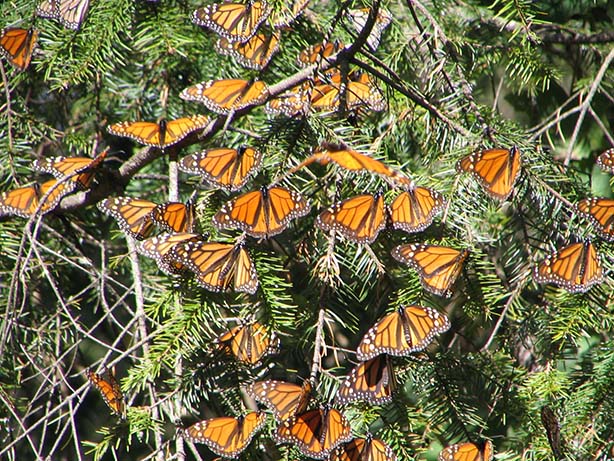
For instance, the monarch butterfly (Danaus plexippus) is one of the most wide-ranging insects in the world, being native to North and South America, the Caribbean, Australia, New Zealand, and other Pacific islands, and also being introduced to Western Europe. The monarch is highly migratory in its North American range. At the end of the growing season, during September and October, adult monarchs undertake along migration to the south, where they spend the winter in one of two small areas. Most venture to central Mexico, where they winter in dense, multi-million populations at only about 12 mountain roosts in the states of Michoacán and Mexico. A much smaller population of western monarchs undertakes a migration to roosts in coastal southern California. The longest migrations are made by monarchs that were born in eastern Canada—these intrepid butterflies travel thousands of kilometres to reach their wintering roosts in Mexico.
When spring comes, the overwintering monarchs begin a northward migration. When they find a sufficient abundance of milkweed plants (Asclepias spp.), the only food eaten by the larvae, the females lay about 400 eggs and die soon afterward. The larvae hatch, feed voraciously, metamorphose into adults after 20-45 days, and then continue the northward migration. After a breeding relay of three to five generations, adult monarchs reach the northernmost parts of their range in Canada, where they breed wherever milkweed is abundant. The last generation of the year, which transforms into adults in September, is the one that undertakes the astonishing southward migration to the wintering roosts in Mexico or California.
The conservation of the monarch butterfly is greatly complicated by its migratory habit, the use of various kinds of ecosystems at different times of the year, and the fact that all of its habitats must be conserved if the species is to survive. However, the greatest conservation risk is the survival of its only 12 winter roosts in Mexico. These critical habitats are in natural forest of oyamel fir (Abies religiosa) that is threatened by deforestation, illegal logging, and tourism development. Although the monarch is an abundant and familiar species, it could quickly become lost from most of its North American range if its winter roosts are not conserved. In addition, the species requires an abundance of milkweeds in its breeding range, and these native plants are being widely depleted by the extensive use of herbicide in agricultural management. As is the case for all transnational species and ecosystems, conservation of the monarch butterfly requires the co-operation of various countries, levels of government, and economic interests.
Image 8.10. Monarch butterflies wintering in Michoacán, Mexico. Source: B. Freedman.
Human-Dominated Ecosystems
Immense areas that were once occupied by natural habitats have been converted into land-uses that serve the human economy in various ways. These human-dominated ecosystems are anthropogenic in the sense that their characteristics are a consequence of environmental conditions associated with the activities of people. The character of these ecosystems may be an intended result of management practices, as is the case of agroecosystems in which crops are grown, or horticultural ecosystems where the intent is more aesthetic. Less-deliberate anthropogenic influences, such as pollution and disturbance, also affect the character of human-dominated ecosystems, often by causing ecological damage.
Of course, human-dominated ecosystems are prevalent wherever people are living in dense populations, such as in cities and towns. But they are also widely prevalent in the countryside where resource-extraction industries such as forestry and mining are important, and in transportation corridors associated with highways and electricity-transmission lines. Because anthropogenic ecosystems are becoming so widespread, and they support relatively few native species, they are the leading cause of the biodiversity crisis, which is characterized by the extinction and endangerment of native species and even of kinds of natural ecosystems (see Chapter 26). There is a great diversity of human-dominated ecosystems, but they can be aggregated into three major categories: urban-industrial techno-ecosystems, rural techno-ecosystems, and agroecosystems.
Urban-industrial techno-ecosystems are typical of urbanized areas and are dominated by the dwellings, businesses, factories, and other infrastructure of society (see Chapter 25). This anthropogenic biome supports many species in addition to humans, but they are mostly alien plants and animals that have been introduced from other regions. Typically, the non-native species cannot live locally outside this biome (other than the foreign biome to which they are indigenous).
Rural techno-ecosystems occur outside of urbanized areas and consist of the extensive technological infrastructure of civilization. These ecosystems include rural transportation corridors (highways, railways, and electricity-transmission corridors) as well as small towns supporting industries involved in the extraction and processing of natural resources. Rural techno-ecosystems support a blend of introduced species, plus those native species that are tolerant of stresses associated with human activities.
Agroecosystems are a complex of habitats that are managed to grow crops for use by humans. The most intensively managed kinds involve monocultures (single-species crops) of plants or animals that are cultivated in agriculture, aquaculture, or forestry. These valuable and necessary crops are grown under conditions that enhance their productivity, although intensive management systems may cause many ecological problems (see Chapter 24). Less-intensively managed agroecosystems may involve the cultivation of mixtures of species (polycultures), and they may provide habitat for some native species. Semi-natural habitats used for the grazing of livestock also support some indigenous biodiversity. When a agroecosystem is abandoned, it slowly reverts to a more natural condition, although it can take many decades before there are ecological communities that are similar to what was originally present, especially in forested regions.
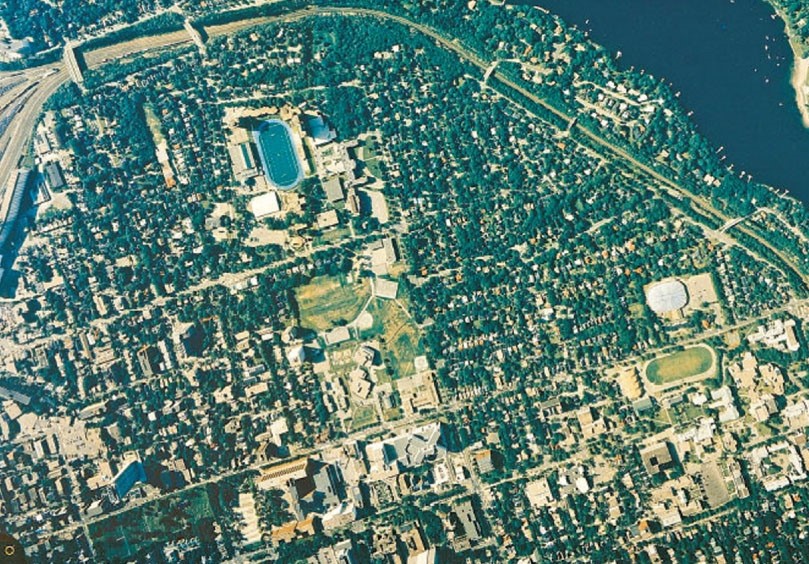
Image 8.11. Urban-industrial techno-ecosystems are dominated by the dwellings, businesses, factories, and other infrastructure of human society. These areas support the economic activities of large numbers of people, and are sustained by enormous flows of resources from the surrounding landscape, and even from other countries. This aerial view of Halifax shows an area used entirely for roads, hospitals, homes, and schools. Source: Nova Scotia Department of Natural Resources.
Ecoregions and Ecozones
As we have learned, biomes are geographically extensive ecosystems that occur anywhere in the world where environmental conditions are suitable for their development, and they are characterized by the life forms of their dominant organisms rather than by their particular species. Learning about biomes is important because it provides insight into the character and environmental influences on major kinds of ecosystems.
Nevertheless, in the practical context of identifying and conserving the species and natural ecosystems of the world, there are limitations to the concept of biomes, mostly because of the non-specificity of their biotic assemblages. If the biodiversity of the world is to be conserved, we need to understand how species are naturally aggregated into communities and larger ecosystems, and how these biotic assemblages are distributed over space and time—there must be enough biogeographic resolution (identification of distinct communities) to conserve the intricate fabric of life on Earth, and biomes do not provide this kind of information.
This problem is dealt with by identifying and mapping extensive units known as ecozones (or as ecoregions). These units are large landscapes or seascapes (ecoscapes) that contain distinct groupings of naturally assembled species and their communities. Like biomes, their spatial boundaries reflect conditions that existed prior to major changes in land-use caused by anthropogenic influences. The distribution of terrestrial ecoregions of the world has been mapped by Olson et al. (2001) and is presented in Figure 8.3. Note that the identity and distribution of the freshwater and marine ecoregions of the world must also be known for the purposes of conservation, but this work has not yet been done.
Figure 8.3. Terrestrial Ecoregions of the World. This map recognizes 867 terrestrial ecoregions, with the greatest amount of diversity occurring in humid tropical realms. Note that this map only covers terrestrial environments—comparable results for freshwater and marine ecoregions are also needed for effective conservation planning, but are not yet available. Source: Modified from Olson et al. (2001).
Terrestrial Ecozones of Canada
The ecosystems found in Canada have been described in various ways, including a hierarchical classification of distinctive types. The largest ecological zones in the national classification are referred to as ecozones. There are 15 terrestrial and 5 marine ecozones in Canada (Figure 8.4). Each of these natural ecozones is characterized by key aspects of the physical environment, such as the climate and dominant landforms, as well as by their natural ecosystems and prominent species. Because so much of the Canadian landscape has been intensively modified through human activities, three anthropogenic ecosystems also occur: urban, agricultural, and industrial.
Figure 8.4. Ecozones of Canada. Canada’s ecozones are described by the nature of their dominant biota and aspects of the physical environment, particularly climate, soil, geology, and other landscape-scale geographic features for terrestrial ecozones, and climate and ice cover for marine ecozones. Source: Modified from Ecological Stratification Working Group (1995).
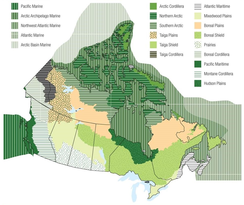
Each of the Canadian ecozones represents a hierarchical agglomeration of distinct ecosystems of more local character. Ecoregions are sub-ecozone units, and are characterized by regional factors related to climate and landform and, to some degree, by soil, vegetation, fauna, and land-use. There are 194 terrestrial ecoregions in Canada. Canada’s marine ecozones have not yet been divided into ecoregions.
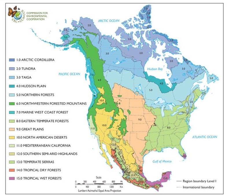
Of course, the boundaries of biomes and ecozones rarely align with political borders. Consequently, all of the southern ecozones of Canada also extend into the United States. Figure 8.5 shows the results of a collaborative ecosystem-mapping study that involved scientists from Canada, Mexico, and the United States (CEC, 1997). This map shows the distribution of the 15 Level-1 ecological regions of North America (these are equivalent in scale and qualities to biomes). In addition, there are 52 Level-2 ecological regions (equivalent to Canadian ecozones). Because countries share ecozones, they also have a mutual responsibility to steward their ecological values. Sometimes, this can lead to conflict if one country believes the other is damaging shared resources or natural ecosystems. For example, Canada and the United States (or particular provinces or states) have ongoing arguments related to such binational issues as the following:
- The effects of raw sewage discharged by the city of Victoria, BC, may be damaging water quality in nearby U.S. waters in Juan de Fuca Strait.
- During seasonal times of high water levels, some of the volume of Devil’s Lake, North Dakota, is released into the Sheyenne River, a tributary of the Red River that runs north into Manitoba. This is done to reduce the risks of flooding on shoreline properties on Devil’s Lake. However, the Government of Manitoba is concerned about down-river flooding as well as the release of alien invasive species into the ecosystem of the Red River.
- There are many environmental issues associated with the jointly managed ecosystems of the Great Lakes, including those related to the diversion of water out of the system to serve U.S. purposes to the south, the release of alien invasive species, and pollution by sewage, agricultural fertilizer and pesticides, and industrial chemicals.
Binational considerations are also relevant to the many species that migrate between their breeding and wintering grounds, which may involve the use of different ecoregions in separate countries. For example, many of the songbirds that breed in Canada spend much of the year in habitats in the United States or in Central or South America. Migratory species of economic value are also an issue, such as species of Pacific salmon that may breed in particular rivers in Canada or the United States, but could be fished in waters of either country, or even in international waters of the high seas. Global Focus 8.1. examines one such example concerning the monarch butterfly, some of which may breed in southern Canada, and then migrate through the United States to reach their hibernating sites in central Mexico.
Figure 8.5. Distribution of the 15 Terrestrial Ecological Regions (Level-1) for North America. These regions are roughly comparable to global biomes. Source: Commission for Environmental Cooperation (1997).
It is beyond the scope of this book to describe the ecozones of Canada in detail. Detailed information is available in Ecological Stratification Working Group (1995) and on the website of the Canadian Council on Ecological Areas (https://web.archive.org/web/20090224235638/http://www.ccea.org/ecozones/index.html). For more details on the Level-1 and -2 ecoregions of North America, see CEC (1997).
Canadian Focus 8.1. Alexandra Fiord: A High-Arctic Oasis
An important field of research in ecology involves undertaking integrated studies of particular ecosystems. Such work is carried out by teams of ecologists, geologists, meteorologists, and other environmental scientists. This sort of work allows scientists to understand the physical, chemical, and biological factors that govern the structure and function of ecosystems and sustain their species.One such project began in 1980, when a team of Canadian scientists working in the tundra biome began to study a place with a relatively moderate climate, known as a high-Arctic oasis. This one in particular is located on a lowland adjacent to the coast of Alexandra Fiord on eastern Ellesmere Island. Their objectives were to describe the plant and animal communities of the oasis and to determine the environmental factors that influence its biodiversity and productivity. Specific research topics included work on the local and regional climate, geology, soils, distribution and species composition of plant communities, ecological productivity, the life histories of prominent plant species, responses of vegetation to experimental manipulations of environmental conditions, and animal populations and their habitat relationships.
This was a multidisciplinary research program, but because all the component studies were carried out in the same place, their results could be integrated to develop a larger picture of the structure and function of the oasis. This kind of understanding is of scientific importance because ecosystems in the Arctic biome have not yet been well studied. The research also contributes to the knowledge required to assess the many kinds of ecological damage that are potentially associated with increasing resource exploitation, ecotourism, and climate change in the Arctic.
The team at Alexandra Fiord found that the climate of the lowland is indeed more moderate than that of the larger landscape. In general, the air and surface temperatures are warmer, soil moisture is greater, and there is less wind. It appears that dark-coloured cliffs on nearby uplands absorb solar radiation and then re-radiate infrared energy that helps to warm the oasis, in a similar manner to how an oven is heated by its hot, enclosing walls. The lowland is also relatively sheltered, so heat-dispersing winds are less vigorous. In addition, snow meltwater from surrounding uplands helps to keep local soils moist, so wet meadows and other communities that depend on abundant moisture can develop.
The moderate environmental conditions allow the lowland to support abundant vegetation, including lush wet meadows dominated by sedge and cottongrass. The communities in drier places are dominated by dwarf shrubs and cushion plants, which are long-lived woody plants that grow no taller than 5 cm above the soil surface. These include avens, bilberry, white heather, arctic willow, and purple saxifrage. Disturbed habitats beside rivers and streams or near human habitations (the lowland contains an abandoned post of the Royal Canadian Mounted Police) support profuse flowerings of herbaceous plants, such as arctic poppy and willow-herb. These plant communities are much more productive than those on the prevailing polar desert that surrounds the lowland, and consequently the oasis supports relatively large populations of animals. The abundant birds include snow bunting, Baird’s sandpiper, hoary redpoll, arctic tern, oldsquaw duck, greater snow goose, rock ptarmigan, parasitic jaeger, and another 19 species. Studies of the Arctic skipper butterfly discovered that its slow-growing larvae take 14 years to accumulate enough energy to undergo metamorphosis to the adult stage, resulting in a remarkably long life cycle.
Because of its relatively small area (only 8 km2), this lowland oasis is not able to support a population of muskox, the most important large herbivore in the larger ecozone. However, small numbers of this impressive animal occasionally feed in the oasis while passing through on their way to larger oases nearby. Sources Henry, G.H.R. 1998. Environmental influences on the structure of sedge meadows in the Canadian Arctic. Plant Ecology, 134: 119–129. Svoboda, J. and B. Freedman (editors). 1994. Ecology of a Polar Oasis. Alexandra Fiord, Ellesmere Island, Canada. Toronto, ON: Captus Press.
Conclusions
Biomes are geographically extensive ecosystems that occur throughout the world wherever environmental conditions are suitable for their development. The same biome may occur in far-flung places, even on different continents, and in such cases it will be similar in structure and function but will usually be dominated by different species. Temperature and moisture availability are the most critical environmental factors affecting the distribution of terrestrial biomes. Marine biomes are most influenced by depth, nutrient availability, and temperature.
The natural landscapes of Canada are divided into biophysical regions known as ecozones—15 terrestrial and five marine. In turn, the ecozones are divided into smaller units known as ecoregions. Ecozones and ecoregions are characterized by their natural landforms, climate, species, and ecological communities. The natural biomes of the world, and the ecozones of Canada, are being rapidly modified by human activities, and many of their inherent biodiversity values are becoming increasingly at risk. These damaging changes are most intensive in regions where people live and work in high population densities, such as in the southern regions of Canada.
Questions for Review
- List five biomes. What are the essential characteristics of each of them?
- What are the characteristics of the ecozones that occur in the province where you live? For detailed information, visit http://canadianbiodiversity.mcgill.ca/english/ecozones/ecozones.htm .
- Select any Canadian ecozone. What are the most important environmental factors affecting the species and ecological communities of that ecozone? Have these factors changed much over the past century or during the past decade? For detailed information on the ecozone, visit the website noted in the previous question.
Questions for Discussion
- Why is it useful to know about the species of plants and animals that live in some defined area, such as a park, county, or province? Is it useful to know about the ecological communities? How does this kind of information assist in planning for conservation and sustainable development?
- Ecologists usually consider native species to have greater “value” than non-native ones. Why do they think this way? Is the rationalization only scientific, or does it include an element of non-objectivity?
- Select any one of the more southerly Canadian ecozones, where human activities have become dominant influences affecting species and ecological communities. Describe any damage that you think human activities might have caused to the native species and natural ecosystems of that ecozone, and consider whether it might be possible to repair any of those effects. For detailed information on the ecozone, visit http://canadianbiodiversity.mcgill.ca/english/ecozones/ecozones.htm.
Exploring Issues
- You have been asked to characterize and map the various ecosystems occurring in a national park (choose one near where you live). How would you determine the distribution and characteristics of the various kinds of terrestrial, wetland, and aquatic ecosystems present in the park?
References Cited and Further Reading
Barbour, M.G. and W.D. Billings. 2000. North American Terrestrial Vegetation,2nd ed. Cambridge University Press, New York, NY.
Begon, M., R.W. Howorth, and C.R. Townsend. 2014. Essentials of Ecology. 4th ed. Wiley, Cambridge, UK.
Bolen, E.G. 1998. Ecology of North America. John Wiley & Sons, New York, NY.
Breckle, S.W. 2002. Walter’s Vegetation of the Earth. The Ecological Systems of the Geo-Sphere, 4th ed. Springer-Verlag, Berlin, Germany.
Commission for Environmental Cooperation (CEC). 1997. Ecological Regions of North America. Toward A Common Perspective. CEC, Montreal, PQ.
Commission for Environmental Cooperation (CEC). 2009a. Terrestrial Ecoregions, 2007. CEC, Montreal. http://www.cec.org/naatlas/maps/index.cfm?catId=7&mapId=15&varlan=english
Commission for Environmental Cooperation (CEC). 2009b. Marine Ecoregions, 2008. CEC, Montreal. http://www.cec.org/naatlas/maps/index.cfm?catId=7&varlan=english
Crabtree, P. (ed.). 1970. The Illustrated Natural History of Canada (9 vol.). NSL Natural Science of Canada, Toronto, ON.
Ecological Stratification Working Group. 1995. A National Ecological Framework for Canada. Environment Canada, Ottawa, ON.
Freedman, B., J. Hutchings, D. Gwynne, J. Smol, R. Suffling, R. Turkington, R. Walker, and D. Bazeley. 2014. Ecology: A Canadian Context. 2nd ed. Nelson Canada, Toronto, ON.
Heywood, V.H. (ed.). 1995. Global Biodiversity Assessment. Cambridge University Press, Cambridge, UK.
National Wetlands Working Group. 1988. Wetlands of Canada. Ecological Land Classification Series No. 24. Environment Canada, Ottawa, ON.
Odum, E.P. 1993. Ecology and Our Endangered Life-Support Systems. Sinauer, Sunderland, MA.
Odum, E.P. and G.W. Barrett. 2004. Fundamentals of Ecology. Brooks Cole, Florence, KY.
Phillips, D. 1990. The Climates of Canada. Environment Canada, Ottawa, ON.
Rowe, J.S. 1972. Forest Regions of Canada. Forestry Canada, Ottawa, ON.
Schultz, J. 2004. Ecozones of the World: The Ecological Divisions of the Geosphere. 2nd ed. Springer Verlag, Berlin, Germany.
Scott, G.A.J. 1995. Canada’s Vegetation: A World Perspective. McGill-Queen’s University Press, Montreal, PQ.
Shelford, V.E. 1974. The Ecology of North America. University of Illinois Press, Urbana, IL. USDA. 2009. Major Biomes Map. United States Department of Agriculture, Natural Resources Conservation Service. Washington, DC. http://soils.usda.gov/use/worldsoils/mapindex/biomes.html
Walter, H. 1977. Vegetation of the Earth. Springer, New York, NY.
Wilkinson, T., J. Bezaury-Creel, T. Hourigan, E. Wiken, C. Madden, M. Padilla, T. Agardy, H. Herrmann, L. Janishevski, and L. Morgan. 2007. Marine Ecoregions Of North America. Commission on Environmental Cooperation, Montreal, PQ
Wiken, E., D. Gauthier, I. Marshall, K. Lawton, and H. Hirvonen. 1996. A Perspective on Canada’s Ecosystems: An Overview of the Terrestrial and Marine Ecozones. Occ. Pap. No. 14. Canadian Council on Ecological Areas, Ottawa, ON.
Woodward, S.L. 2003. Biomes of the Earth: Terrestrial, Aquatic, and Human-Dominated. Greenwood Press, Oxford, UK.